URGENT – WINTER WEATHER MESSAGE
Issued 5:26 AM EST Saturday, Jan 24 2026
By the National Weather Service Baltimore MD/Washington DC
MAJOR WINTER STORM WILL IMPACT THE REGION THIS EVENING THROUGH SUNDAY EVENING
A large area of precipitation will overrun Arctic air in place over the Mid-Atlantic. This will lead to widespread significant snow beginning this evening, with the potential for ice Sunday especially south of Highway 50 and near and east of Interstate 95. In addition to the high threat for significant snow and ice, very cold temperatures are expected tonight through the middle of next week with sub-zero wind chills likely at times.
Warren-Clarke-Rappahannock-Northern Fauquier
WINTER STORM WARNING REMAINS IN EFFECT FROM 11 PM THIS EVENING TO 4 AM EST MONDAY
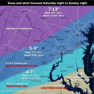
* WHAT…Heavy mixed precipitation expected. Total snow and sleet
accumulations between 10 and 16 inches, with highest amounts north and west of US-340. Ice accumulations up to two tenths of an inch, mainly south and east of US-340.
* WHERE…Portions of north central and western Maryland, northern
and northwest Virginia, and eastern and panhandle West Virginia.
* WHEN…From 11 PM this evening to 4 AM EST Monday.
* IMPACTS…Travel could be very difficult to impossible.
* ADDITIONAL DETAILS…Snow will likely overspread the area tonight, becoming heavy at times with rates of one to two inches per hour possible at times. A mix with sleet or freezing rain is expected Sunday. Visibility of one-quarter mile or less is possible at times. A prolonged period of very cold wind chills continues this
evening and lasting through the middle of next week.
PRECAUTIONARY/PREPAREDNESS ACTIONS…
If you must travel, keep an extra flashlight, food, and water in your vehicle in case of an emergency. The latest road conditions for the state you are calling from can be obtained by calling 5 1 1.
Persons should consider delaying all travel. Motorists should use
extreme caution if travel is absolutely necessary.